I just returned from three weeks in Xinjiang-Uighur Autonomous Region, a really special place for photography (and other things).
My route took me from the capital Urumqi - Kashgar - Karakul - Tashkurgan (near Pakistan border) - back to Kashgar - Yengisar (South Silk Road) - Yecheng - Hotan - Niya - across the Taklamakan on the Cross Desert Highway - Korla - Turpan - back to Urumqi.
Urumqi, Kashgar, Karakul, Yengisar and Turpan see plenty of tourists. The remainder, particularly around Niya further south and all the way through the desert, are fairly remote and not touristed at all (even by Chinese it seems).
Xinjiang remains largely unknown to people not familiar with China, but is a treasure trove of things to look at, eat and do. Over the next several days, I'll post a few photos from each area I passed through and add a few comments about that photo.
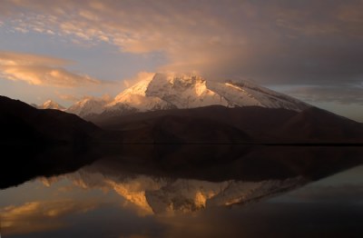
**Note for this photo: This is another sunrise shot of Muztagh Ata, at 7546m, one of the highest mountains in the world. Different light and timing from my other sunrise photo of the same mountain. At the base of the mountain is Karakul Lake (3600m), the highest lake on the Pamir Plateau, also near the junction of the Pamir, Tian Shan and Kunlun Shan mountain ranges. The lake is known for its brilliant reflections. Some travellers (including myself) spend a night or two in a yurt with some local people. This is the best way to enjoy the lake, since around noon, loads of day-trippers come down from Kashgar to have a look around. They stay for 2-3 hours then are on their way back again, meaning overnighters can have the place to themselves.
Karakul is also close to the point where China, Tajikistan, and Afghanistan meet, as we passed by the turnoff for Tajikistan, some 15-20km before the lake.
This is the kind of photo one should contemplate on the first day of the New Year! So,I'll make it a favourite and look at it at leisure! Happy New Year,James! YT


")

